RETURN TO TK and GMAN WEBSITE

Monday, June 25, 2018

The Enchanted Circle of New Mexico

PART ONE:  HOT, DRY, MISERABLE

It was time for another motorcycle trip so at the end of June, 2018, we loaded up the Harley and headed west.  Red River, New Mexico, would be our home base for a few days as we explored the 83-mile loop, known as The Enchanted Circle, which runs through the mountains, valleys and national forests of Northern New Mexico.  

For accommodations we chose the WorldMark Red River which is within walking distance of the center of the village of Red River.  Our stay at the WorldMark included a two-bedroom suite complete with our own kitchen and balcony overlooking a popular honey-hole for trout fishing along the banks of the Red River.  

Many deer in Red River will take food from your hand

Another deer

We watched this man from Oklahoma snag a nice rainbow

We spotted one Golden Trout among all the Rainbows


It seemed that fishing this honey hole was about the only activity one could participate in due to fire bans. Weeks before our arrival there was a forest fire in Ute Park which burned approximately 36,000 acres.  Combining that with the fact that the area was experiencing an extreme drought meant that the Kit Carson National Forest was off limits to any type of use including fishing, hiking, camping and ATV use.

All areas of the Kit Carson National Forest was closed due to drought and fire

In this photo you can see how dry Eagles Nest Lake was in June of 2018

Not sure if they were practicing or letting water out of their tanks but we happened upon a fire crew from Wheeler Peak and Red River working


Old mining truck in middle of Red River, New Mexico


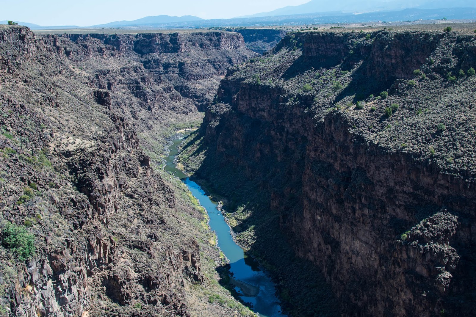
Fortunately, that didn't stop us from roaming the Enchanted Circle via motorcycle on paved roads!  We began our drive by heading west of Red River through Questa, New Mexico, and on into Taos, New Mexico, where we stopped to visit the Rio Grande Gorge and the Taos Pueblo.

Bridge that crosses Rio Grande Gorge

Kind of sad but we suppose there are a lot of jumps from the bridge

Rio Grande River runs through the gorge

Archaeologists believe that the ancestors of the Taos Indians lived in the Taos Valley long before Columbus discovered America.  The main part of the Taos Pueblo buildings were most likely constructed between 1000 and 1450 A.D.  They appear today as they did when the first Spanish explorers arrived in Northern New Mexico in 1540 and believed that the Pueblo was one of the fabled golden cities of Cibola.   

Church in the middle of the Taos Pueblo

Taos Pueblo with rain clouds behind

Beautiful Taos Pueblo - can you tell why the Spaniards through it was made of gold?

Many relatives of the Taos People still own homes within the Pueblo and sell their wares and specialty treats for visitors such as ourselves.  We visited with one man who's family has owned a house within the Pueblo since it was first built.  Although they do not live in it now the family returns for special celebrations.  He explained to us the different types of foods that would be prepared for their cultural celebrations and the different types of ovens used to cook their bread.  We purchased a fry bread from him which he freshly prepared for us from within his family's home.  We enjoyed our delicious snack sitting under a tree near the Rio Pueblo de Taos, or the river that runs through the Taos Pueblo.  We visited with another man from the Taos Pueblo and asked when he thought it was going to rain.  We loved his answer as he remarked, "it won't rain until people start acting right."  As we left Taos, New Mexico, we could see rain clouds in the direction we were headed - towards Angel Fire, New Mexico.

As we moved closer to Angel Fire the hot June temperatures dropped and a cool breeze began to blow.  We joked that perhaps people were "acting right" but we were only disappointed when the clouds disappeared and the sun returned to beat down on our backs.

And that is just how the rest of our trip went!  The wind blew hot and dry.  No rain eased our discomfort or the pour discomfort of the dried up New Mexico high desert.  Miserable, we left our beloved New Mexico vowing never to return.


PART TWO:  THE RAINS CAME!

Not being able to stay away from New Mexico for very long, TK headed to Angel Fire, New Mexico, during the end of August, for a short trip with family.  Upon arrival at the Sante Fe airport we were greeted, again, by those hot dry winds which brought back the bitter memory for June. Luckily, as we drove from Sante Fe to Angelo Fire we were greeted by the dark blue and purple rain clouds we had longed for just months before.  Green had returned to the valleys and trees. Red, purple and yellow wildflowers danced in every field.  The rains had come! New Mexico was welcoming us back!


San Antonio church outside of Angel Fire, New Mexico

Window at Our Lady of Guadalupe church in Taos, New Mexico

Purple and blue rain clouds over Santa Fe National Forest

Sun going down over Ute Valley near Angel Fire, New Mexico


Rain clouds over field at Ute Valley

Beautiful colors of New Mexico, that land of enchantment

Sunday, June 10, 2018

Return to Oregon

Hands down one of our favorite places to visit is the beautiful state of Oregon.  So this year, when summer vacation rolled around, we just couldn't resist returning to the Beaver State but this time we brought family!

Flying into Portland

Entering Troutdale

We flew into Portland on a rainy day (what else would you expect?) in June, rented a car and skipped over to Troutdale, the small town known as the Gateway to the Gorge.  For a quick bite of lunch at the Ye Old Pub before entering the Columbia River Gorge via the Historic Columbia River Highway.  Years before we had driven this same road stopping to hike some of the waterfalls along the highway, however, this time we had several factors keeping us from exploring:  1. the rain, 2. elderly parents in tow, and 3. the Eagle Creek Fire.

Wet, cold Historic Columbia River Highway

View from the Vista House at Crown Point overlooking the Columbia River

Opposite direction view from the Vista House at Crown Point overlooking the Columbia River

OLD PHOTO - Multnomah Falls 2015

The Eagle Creek Fire was a destructive wildfire in the Columbia River Gorge in the U.S. states of Oregon and Washington. The fire was started on September 2, 2017, by a 15-year-old teenage boy igniting fireworks during a burn ban. The fire burned 50,000 acres, and burned for three months, before being declared completely contained. As of May 29th 2018 it was found still smoldering in some areas.

Unfortunately, most of the waterfalls were barricaded so that you could not get to them.  The lower half of Multnomah Falls, one of the most impressive along the gorge, was only accessible from the Highway 84 and not the Historic Columbia River Highway.

We called the falls a miss and drove on into Cascade Locks where we had reserved a hotel for the night. Our favorite hotel in Cascade Locks is the Best Western Columbia River Inn.  This clean, well kept, hotel sits along the banks of the Columbia River.  We made sure to get a river view room so that we would not miss the barges going up and down the big river.  Still raining we decided to take a driving tour of the area and visited the Bonneville Fish Hatchery, Bonneville Damn, Bridge of the Gods and Thunder Island Brewing (you know us!). 

Marionberry Sour Beer at Thunder Island Brewing overlooking the old locks at Cascade Locks

Fragrant lavender grows thick at the Bonneville Fish Hatchery

Beautiful old train bridge greets you at the entrance to the Bonneville Fish Hatchery

View from Best Western Inn at Cascade Locks

Mural of cascades below the Bridge of the Gods

Mural below the Bridge of the Gods and the ONLY bigfoot we saw on our whole trip.  His nose is very European, don't you think?

Bridge of the Gods

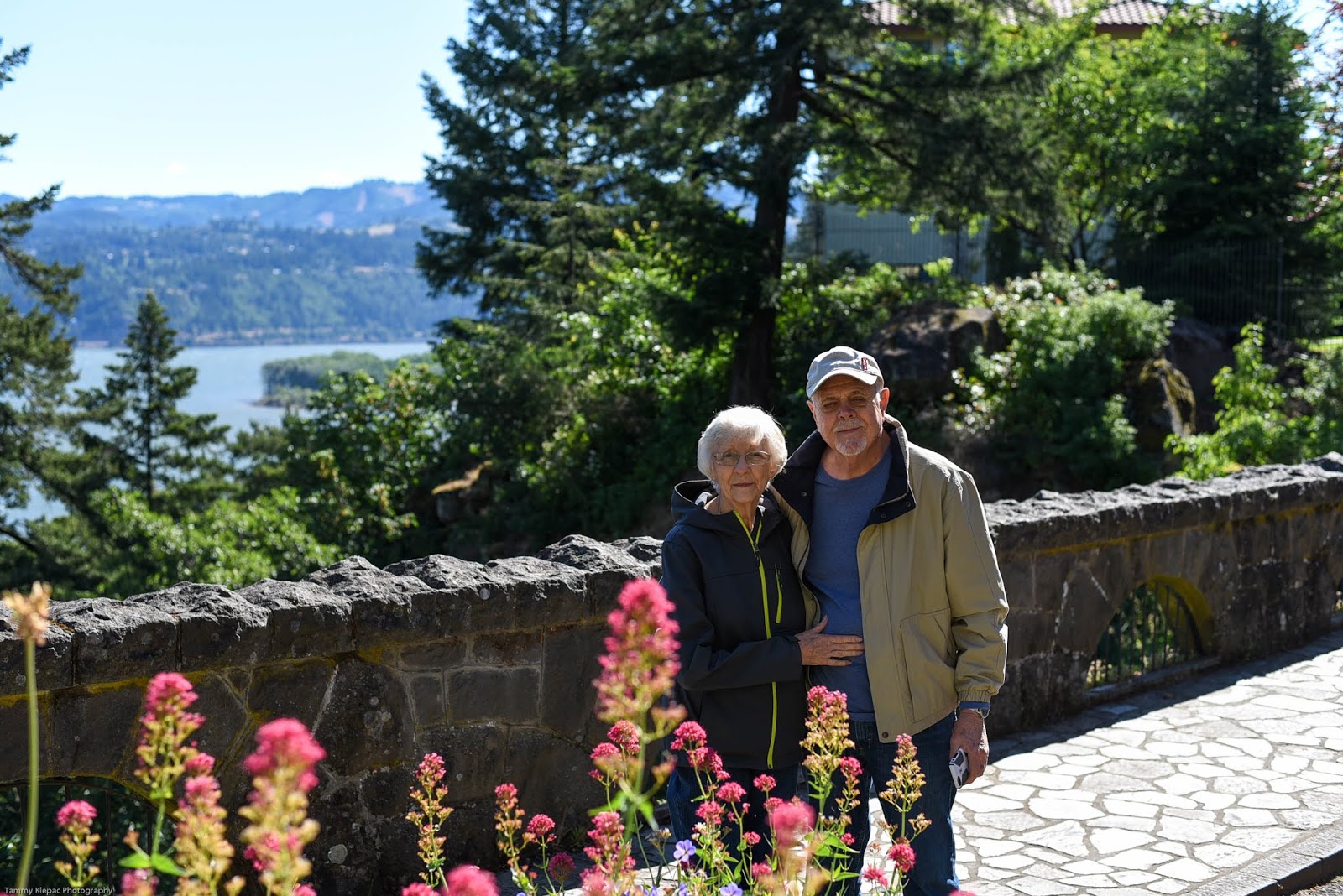
The next day we headed to Hood River stopping to view the gardens and Columbia River overlook at the Columbia Gorge Hotel & Spa.

Mom & Dad at the Columbia Gorge Hotel & Spa

Bridge in the beautiful gardens surrounding the Columbia Gorge Hotel & Spa

From Hood River we drove up to Mount Hood stopping to take in the sites along the way. Our first stop was Packers Farm Place, just off Highway 35, to pick up some snacks - Mount Hood cherries and dried apples!

Mount Hood view from a farm near Hood River, Oregon

Inching closer to Mount Hood we made another detour on the Barlow Road.  This poorly paved road winds through a dense forest passing by the Pioneer Woman's Grave where you can stop and leave your trinket in honor of the pioneers who made their way through this area.  The road continues until the forest opens up and reveals the best view of Mount Hood, or, Wy'East the Legendary Mountain, as Native Americans have named it. Directly across from the Wy'East lookout point is a quaint rock water basin which is filled from a mountains spring above the basin.

Basin across from Wy'East Lookout

View of Wy'East - the Legendary Mountain from the Barlow Road

It was getting close to lunch time when we made our way up to Mount Hood where we watched a few people skiing in June and we roamed the Timberline Lodge taking a break from our car ride.

Outside of Timberline Lodge - used in the movie, The Shining

We said goodbye to Wy'East and headed down the mountain and west on to the Pacific Coast.  We had reservations at our favorite inn in Cannon Beach, Schooner's Cove Inn, for the next three nights.

As usual the Schooner's Cove Inn and Cannon Beach did not disappoint!  Each room at the inn has their own kitchenette and gas burning fireplace - perfect for the cool nights on the beach.  Using Cannon Beach as home base we explored the area visiting Hug Point, Haystack Rock, Ecola State Park, Lewis & Clark Salt Cairns, The Wreckage of the Peter Iredale and the Astoria Column in Astoria, Oregon.  Because we have visited these places before and posted our experiences on this blog we're not going to go into details.  We'll just let our photos speak for themselves.

View of Tillamook Lighthouse from our hotel balcony at Cannon Beach

Wreck of the Peter Iredale on the beach near Fort Clatsop

Beach view overlook from Ecola State Park

Mom and Dad exploring the beach at Cannon Beach

Haystack Rock near Cannon Beach
Astoria Column in Astoria, Oregon

TK's bird friend she hand fed pizza crust

Lewis & Clark Salt Cairns Historic Monument


Needless to say, we enjoyed our trip to Oregon once again and plan to return next year!

Until next year!

Monday, March 12, 2018

Fredericksburg, Texas

It was SPRING TIME and both of us had a week off of work! We loaded up the trailer and traveled south through the beautiful Texas Hill Country to Lady Bird Johnson Municipal Park, outside of Fredericksburg, Texas. 

Plenty of unique shopping in downtown Fredericksburg

St. Mary's Catholic Church

This truck is parked outside an art gallery.  Only in Texas is this advertising!

Biergarten at at the Auslander

The old hospital of Fredericksburg now houses a kitchen shop


Fredericksburg is a city in central Texas, known for its wineries. The city's German heritage is on display throughout the town and especially at the Pioneer Museum, which features settlers' homesteads and artifacts. We really enjoyed visiting this living history museum talking with the volunteers dressed in period clothing.

German kitchen or kuchen

Oma forgot her bonnet

Recreated bath house

Blacksmith

Character from the past playing a wash tub

Oma showed us how to knit with three needles

This trapper was skinning a real raccoon

In the nearby town square, Marktplatz, the Vereins Kirche is a replica of a 19th-century German church that once stood in the city. The vast National Museum of the Pacific War features WWII exhibits, including a recreated combat zone.

Vereins Kirche - replica of a German church

National Museum of the Pacific War

The crown jewel of Fredericksburg’s recreational parks is the 150 acre Lady Bird Johnson Municipal Park. Rolling hills and rambling Live Oak Creek set the stage for a beautiful day. It is a place to rest, relax and enjoy nature. Five pavilions serve as the spot for birthday parties, class and family reunions, school field trips, weddings and more. Baseball/softball fields are available for a casual game or can be reserved. A sand volleyball court and outdoor basketball courts are available. The park offers a beautiful setting for large and small groups no matter the occasion. Located 3 miles south of downtown off of Hwy. 16 S. 

Our homestead for the next few days was the Lady Bird Johnson RV Park which sits adjacent to the Lady Bird Johnson Municipal Park.  This RV park features 98 RV spaces with 30 and 50 amp electrical hook-ups, water, sewer and cable TV.  Although the sites were very close together (actually back to back) the park was clean and family oriented.

Lady Bird Johnson Municipal Park Sign
Fishing along Live Oak Creek near Lady Bird Johnson Municipal Park


Nestled along Baron's Creek at the eastern edge of Fredericksburg is Fort Martin Scott.  This fort was the first U.S. military post be established on the western frontier of Texas.  Today is is an historical treasure listed on the National Register of Historic Places.  Visitors are allowed to roam around the fort, free of charge, and reflect upon the importance that the fort played in the development of the great State of Texas.

Fort Martin Scott entrance

Rebuilt areas and remnants of the old fort

Limestone kitchen/storage area of the fort

A trip to the Texas Hill Country is not complete without a stop at Luckenbach, Texas. Luchenbach began as a trading post in 1849, making it one of the oldest settlements in Gillespie County. 


Proudly flown over the post office at Luckenbach

Inside the general store/beer joint hang a memorial to Hondo, Luckenbach's most famous citizen

Outdoor access to the important stuff - beer!

The post office and general store/beer joint was opened in 1886 by August Engel.  Today the tiny hamlet boasts that "everybody is somebody" in Luchenbach, and under its it is the perfect escape for road weary travelers who want to escape the Texas heat under a shady canopy of live oak trees while listening to a variety of Hill Country musicians.


Plenty of shade, character's and music under the live oak trees

We're not sure if the population of Luckenbach includes these chickens

In case you get lost, look for the signs